
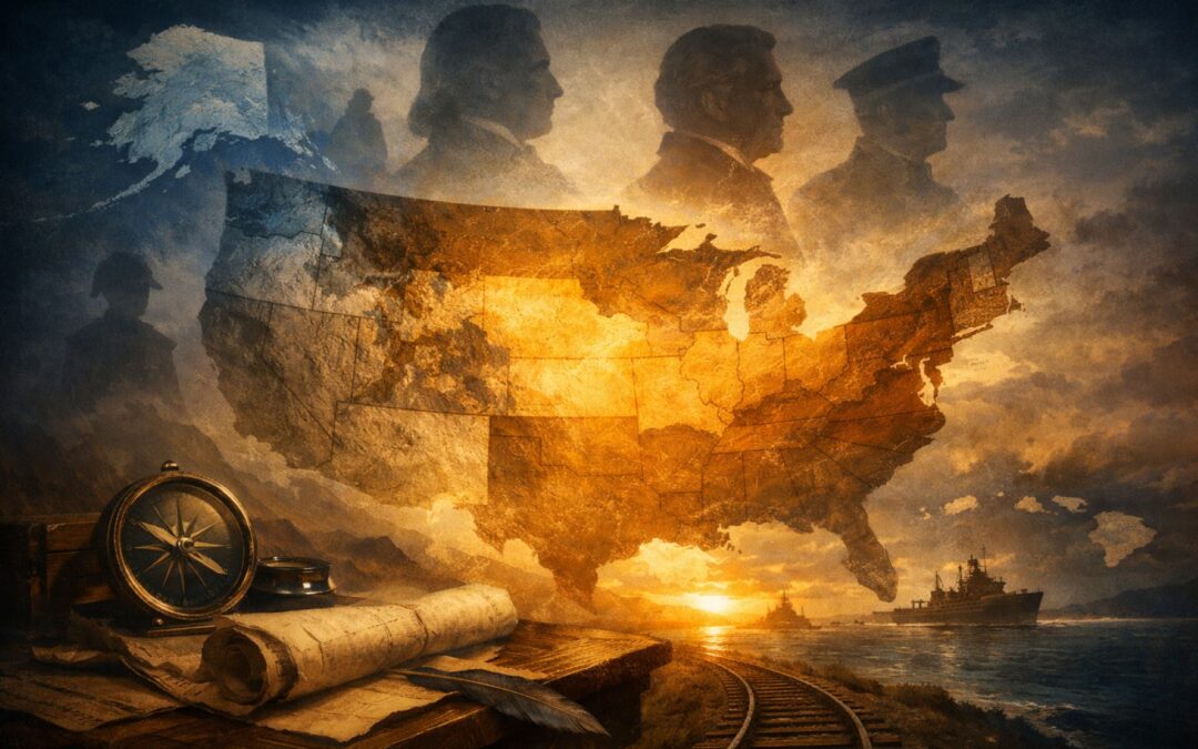
Introduction: From Coastal Republic to Continental Power
In 1783, when the Revolutionary War ended, the United States was a fragile experiment hugging the Atlantic coastline. Its territory stretched from the Atlantic Ocean to the Mississippi River, bordered by British Canada to the north and Spanish Florida and Louisiana to the south and west. It was not yet a continental power. It was a narrow republic surrounded by empires.
Within a century, that would change dramatically.
Through a combination of bold purchases, calculated diplomacy, opportunistic intervention, and outright war, successive presidents reshaped the map of North America. The United States doubled in size overnight, pushed its borders to the Pacific, acquired distant islands, and eventually emerged as a global power with territory stretching across multiple oceans.
These expansions were not random. Each followed a recurring logic: secure trade routes, eliminate rival powers, protect borders, expand economic opportunity, or project military strength. Some were peaceful transactions. Others were deeply controversial acts of conquest. Many carried consequences that still shape geopolitics today.
From the Louisiana Purchase to the Treaty of Guadalupe Hidalgo, from the annexation of Hawaii to modern discussions about Greenland, the story of American territory is inseparable from the story of presidential power.
This is the history of how U.S. presidents expanded America — and how those decisions transformed the country from a boxed-in republic into a continental and eventually global force.
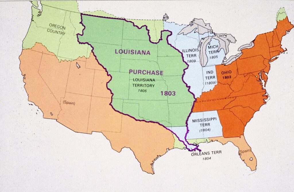
The Louisiana Purchase (1803): The Deal That Doubled America
The first great leap westward came under Thomas Jefferson — and it fundamentally altered the trajectory of the United States.
At the turn of the nineteenth century, control of New Orleans meant control of the Mississippi River. For American farmers in Kentucky, Tennessee, and the Ohio Valley, that river was the economic lifeline to global markets. If a foreign power blocked access, the young republic’s western economy could collapse.
At the time, France controlled Louisiana. And France was led by Napoleon Bonaparte, who initially envisioned rebuilding a French empire in North America. Jefferson feared that a powerful France on America’s western border would pose a serious strategic threat.
So Jefferson authorized envoys James Monroe and Robert Livingston to purchase New Orleans — and perhaps a small buffer of surrounding land — for up to $10 million.
Instead, they were offered something extraordinary.
Napoleon, facing financial strain from European wars and the devastating slave rebellion in Haiti, decided Louisiana was more liability than asset. He offered to sell the entire Louisiana Territory — more than 828,000 square miles — for $15 million.
The deal, formalized as the Louisiana Purchase, effectively doubled the size of the United States overnight. For roughly four cents per acre, America gained land stretching from the Mississippi River to the Rocky Mountains, and from the Gulf of Mexico to present-day Canada.
Jefferson himself wrestled with the constitutionality of the purchase. The Constitution did not explicitly authorize acquiring foreign land. As a strict constructionist, he had long argued for limited federal power. Yet he ultimately concluded that the strategic opportunity outweighed his reservations.
The consequences were immense:
- Secured permanent access to the Mississippi River
- Opened vast lands for westward migration
- Laid the groundwork for the Lewis and Clark expedition
- Ultimately produced 15 future states
The Louisiana Purchase was not a conquest by war, but it was a decisive act of executive ambition. It signaled that the United States would not remain confined to the eastern seaboard. It would grow — and it would grow aggressively when opportunity appeared.
The pattern was set.
West Florida and the Madison Expansion (1810–1813)
If Jefferson expanded the nation through an extraordinary bargain, James Madison expanded it through opportunism.
In 1810, a narrow strip of land along the Gulf Coast — known as West Florida — was still technically controlled by Spain. However, American settlers had been steadily moving into the region for years. Frustration grew over Spanish administration, and in September 1810, local settlers declared independence and established the short-lived Republic of West Florida.
The new republic lasted only 90 days.
Madison quickly proclaimed that the territory was already part of the Louisiana Purchase and therefore rightfully American. He ordered U.S. troops to occupy the region. By 1813, the United States had absorbed approximately 20,000 square miles of land that now form parts of modern-day Alabama, Mississippi, and Louisiana.
Spain protested, but its empire was overstretched. Napoleon had invaded Spain in Europe, and independence movements were erupting throughout Latin America. Madrid lacked the resources to meaningfully resist American encroachment.
This episode marked an important shift in American expansion:
- It blurred the line between purchase and seizure
- It relied on local rebellion as a pretext
- It exploited the weakness of a declining European power
Unlike the Louisiana Purchase, which came through formal negotiation, West Florida was acquired through assertion backed by military force. It demonstrated that American leaders were willing not only to buy territory — but to reinterpret borders and act decisively when opportunity emerged.
The Gulf Coast was becoming American. And Florida itself would soon follow.
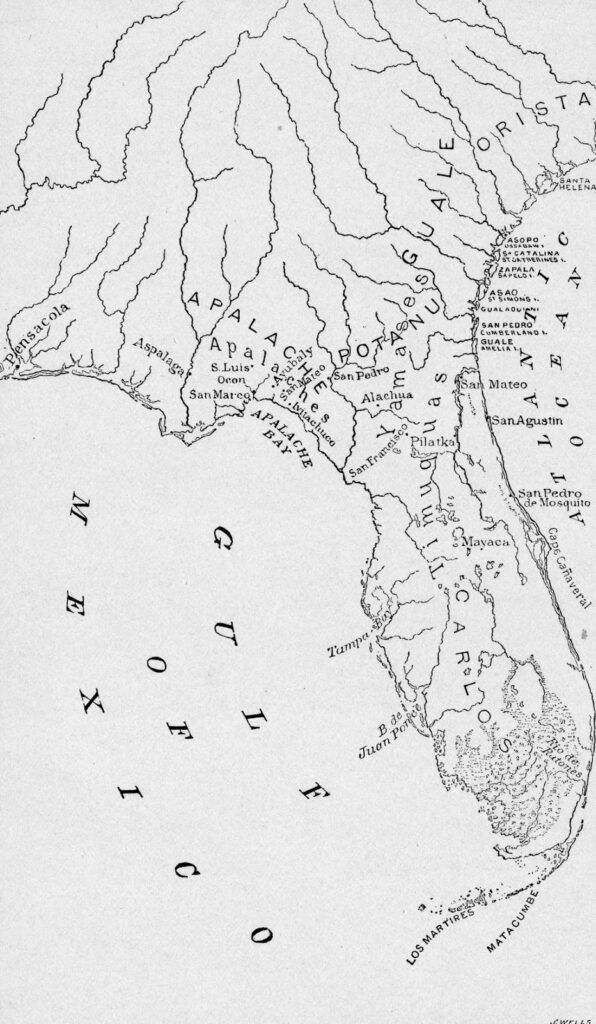
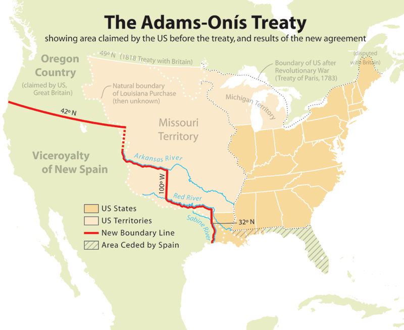
Florida and the Adams–Onís Treaty (1819)
After West Florida fell into American hands, the rest of the peninsula remained under Spanish control. But Spain’s hold on Florida was rapidly weakening.
Under James Monroe, the United States moved to resolve the issue permanently. The immediate catalyst was instability along the border. Seminole groups based in Spanish Florida conducted raids into Georgia, and enslaved people fleeing the American South sought refuge there. Tensions escalated.
In 1818, General Andrew Jackson, then operating under Monroe’s administration, launched a campaign into Spanish Florida during the First Seminole War. Jackson captured Spanish forts and executed two British citizens he accused of aiding Native resistance. His actions nearly sparked an international crisis.
Yet instead of condemning Jackson, American leaders used the situation as leverage.
Spain was already facing revolutionary movements across its empire in Latin America and lacked the strength to maintain control over Florida. Negotiations culminated in the Adams–Onís Treaty, brokered by Secretary of State John Quincy Adams.
Under its terms:
- Spain ceded East and West Florida to the United States
- The U.S. assumed $5 million in claims by American citizens against Spain
- A boundary between Spanish Texas and U.S. territory was formally established
In effect, Spain relinquished 72,000 square miles of territory and exited the region entirely.
Florida became officially American in 1821.
Just a few years later, in 1823, Monroe articulated what became known as the Monroe Doctrine. It declared that European powers should no longer colonize or interfere in the Western Hemisphere. The United States was signaling that it viewed the Americas as its sphere of influence.
Florida’s acquisition was more than a border adjustment. It represented a transition in American thinking — from defensive consolidation to regional assertion. The young republic was no longer simply expanding. It was defining its dominance in the hemisphere.
The next expansion would be far more explosive.
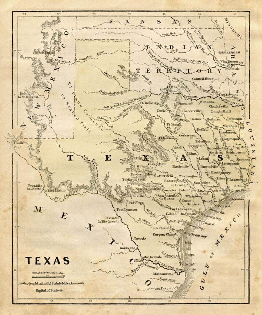
Texas Annexation (1845): Expansion at the Edge of War
By the 1840s, the question was no longer whether the United States would expand — but how far it would go.
Texas had broken away from Mexico in 1836 after a rebellion that included the famous Battle of the Alamo. For nearly a decade, the Republic of Texas functioned as an independent nation with its own government, currency, and diplomatic ties. However, Mexico never recognized its independence and continued to claim the territory.
When James K. Polk took office in 1845, he was committed to expansion under the banner of Manifest Destiny — the belief that the United States was destined to stretch from the Atlantic to the Pacific.
Texas wanted to join the Union. Mexico warned that annexation would mean war.
Polk pushed forward anyway.
On December 29, 1845, Texas was admitted as the 28th state. The annexation added roughly 389,000 square miles of land and extended the United States to the Rio Grande — at least according to American claims. Mexico insisted the border lay further north at the Nueces River.
The dispute over that boundary would ignite the next phase of expansion.
Polk deployed American troops under General Zachary Taylor into the contested territory. When fighting broke out in 1846, Polk declared that Mexico had shed “American blood on American soil.” Congress approved a declaration of war.
Texas annexation was not merely a territorial addition. It was the spark that triggered one of the most consequential conflicts in American history — a war that would permanently reshape the map of North America.
The continental United States was about to stretch all the way to the Pacific.
The Oregon Settlement (1846): Negotiation Instead of War
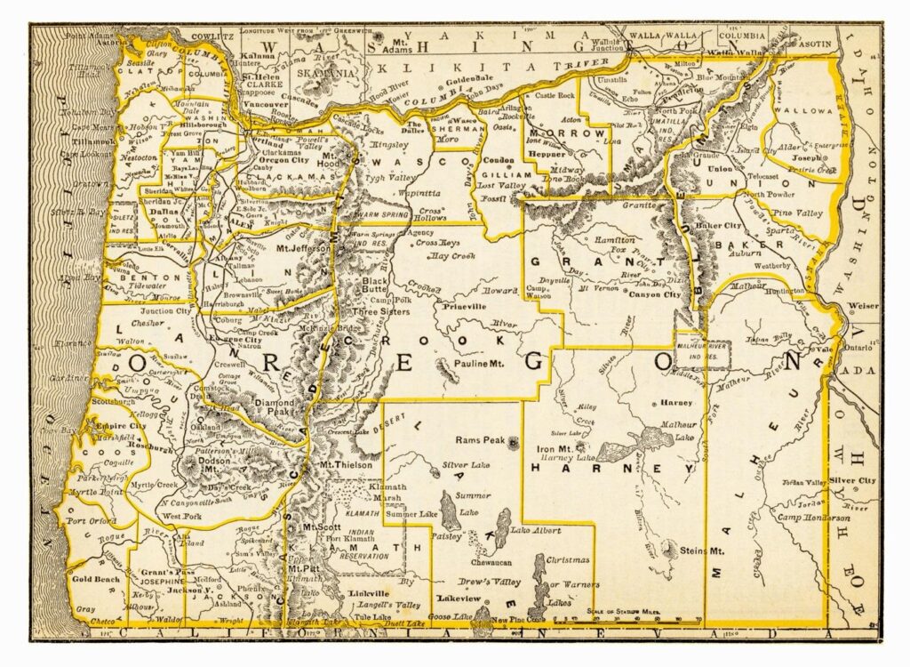
While tensions with Mexico were escalating in the south, another territorial dispute was unfolding in the north.
The Oregon Country — a vast region encompassing present-day Oregon, Washington, Idaho, and parts of Montana and Wyoming — had been jointly occupied by the United States and Britain since 1818. Neither side had exclusive sovereignty, and for decades the arrangement held.
But by the 1840s, American settlers were pouring westward along the Oregon Trail. The demographic balance was shifting. Expansionists demanded full American control.
During the 1844 presidential campaign, James K. Polk embraced the slogan “54°40′ or Fight,” referring to the northernmost latitude of the Oregon Territory. Expansionists argued that the United States should claim the entire region up to Russian Alaska.
Yet Polk faced a strategic dilemma. War with Mexico was already brewing. A simultaneous conflict with Britain — the world’s dominant naval power — would be disastrous.
Instead of escalating, Polk compromised.
In 1846, the United States and Britain signed the Oregon Treaty. The agreement set the boundary at the 49th parallel, which remains the border between the United States and Canada west of the Great Lakes.
The outcome secured approximately 286,000 square miles of territory for the United States — including access to the Pacific Northwest’s coastline — without a single battle.
The Oregon settlement demonstrated a different mode of expansion. Not every territorial gain required war. Sometimes demographic pressure, diplomatic leverage, and calculated compromise achieved the same strategic objective.
With Oregon secured peacefully, Polk turned his full attention south — where war with Mexico would produce the largest single territorial acquisition in American history.
The Mexican Cession (1848): War and a Vast New Southwest
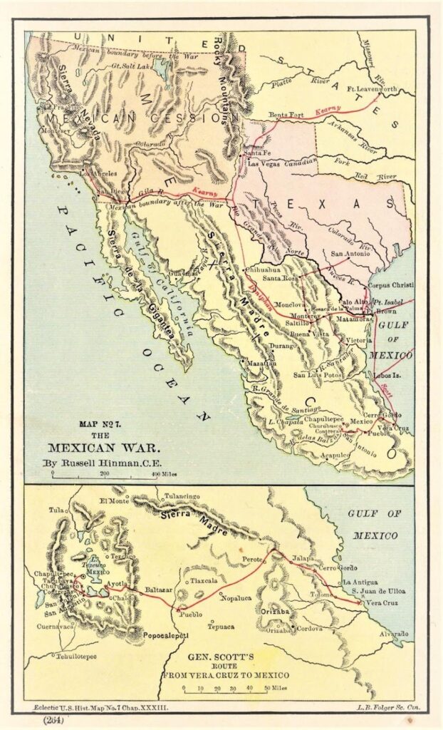
The annexation of Texas ignited the conflict. What followed reshaped the continent.
The Mexican–American War (1846–1848) was swift and decisive. American forces advanced from multiple directions — General Zachary Taylor in the north and General Winfield Scott launching an amphibious assault on Veracruz before marching inland toward Mexico City.
By September 1847, U.S. troops had captured the Mexican capital.
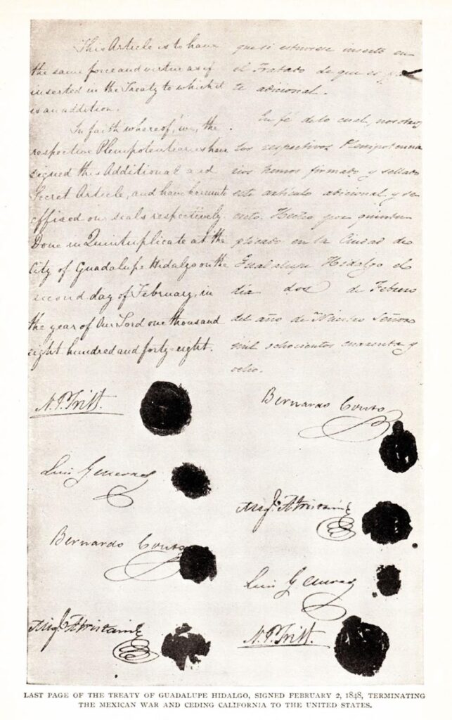
The war ended with the Treaty of Guadalupe Hidalgo. Under its terms:
- Mexico ceded approximately 530,000 square miles of territory
- The United States paid $15 million
- Mexico recognized the Rio Grande as the Texas border
The newly acquired land included present-day California, Nevada, Utah, and large portions of Arizona, New Mexico, Colorado, and Wyoming.
The scale of the acquisition was staggering. The United States now stretched from the Atlantic to the Pacific.
And then came the twist.
In 1848, just days before the treaty was signed, gold was discovered at Sutter’s Mill in California. The California Gold Rush of 1849 triggered one of the largest migrations in American history. Hundreds of thousands moved west, transforming the region almost overnight.
By 1850, California entered the Union as a state.
The Mexican Cession was the largest single territorial gain achieved through war in American history. It completed the vision of a continental nation — but it also intensified sectional conflict over slavery in the new territories, helping set the stage for the Civil War.
Expansion had achieved its geographic goal. Now it would produce political consequences that nearly tore the country apart.
The Gadsden Purchase (1853): Finalizing the Southern Border

By 1850, the continental outline of the United States was largely complete. But there was one practical problem: transportation.
The newly acquired Southwest was rugged and mountainous. Engineers looking to build a southern transcontinental railroad concluded that the best route ran slightly south of the existing border — through land still controlled by Mexico.
Under Franklin Pierce, the United States moved to correct that.
In 1853, American diplomat James Gadsden negotiated an agreement with Mexico to purchase a strip of land covering approximately 30,000 square miles in what is now southern Arizona and New Mexico. The United States paid $10 million for the territory.
The agreement, known as the Gadsden Purchase, finalized the southern boundary of the contiguous United States.
Unlike earlier expansions fueled by ideology or war, this acquisition was driven by infrastructure. It reflected a new phase of expansion — one focused not on acquiring vast frontiers, but on refining and optimizing the territory already gained.
With the Gadsden Purchase, the recognizable continental map of the United States was complete.
But expansion did not stop at the coastline. Soon, American leaders would look beyond the mainland — toward distant territories and global influence.
Alaska (1867): From “Seward’s Folly” to Strategic Asset
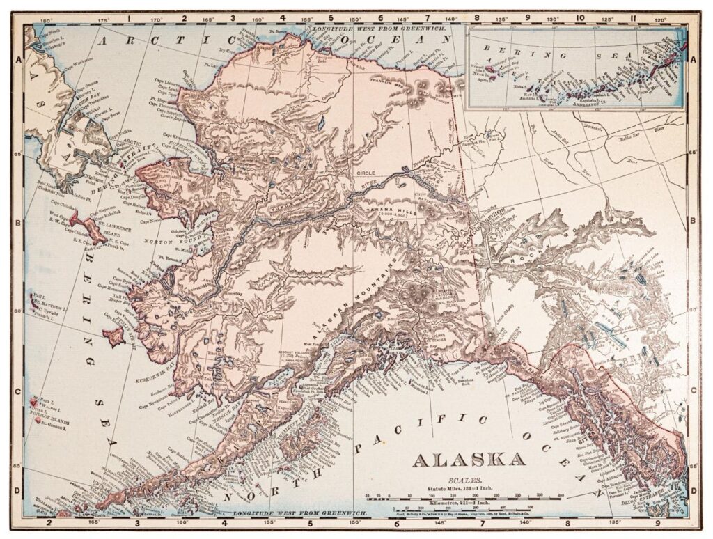
After the Civil War, the United States turned its attention north.
Russia had controlled Alaska since the eighteenth century, but by the 1860s the empire was financially strained. The recent Crimean War had weakened Russia, and leaders feared that if another conflict erupted, Britain — already dominant in nearby Canada — might seize Alaska without compensation.
Under Andrew Johnson, Secretary of State William H. Seward negotiated a deal with Russia.
In 1867, the United States agreed to purchase 586,000 square miles of territory for $7.2 million — about two cents per acre.
The agreement, commonly called the Alaska Purchase, was ridiculed at the time. Critics labeled it “Seward’s Folly” and “Seward’s Icebox,” arguing that America had wasted money on a frozen wilderness of little value.
History proved otherwise.
In the 1890s, gold discoveries triggered the Klondike Gold Rush, drawing thousands north. In 1968, vast oil reserves were discovered at Prudhoe Bay. Over time, Alaska became a major source of oil, natural gas, fisheries, and minerals.
Strategically, Alaska also positioned the United States in the Arctic and placed it directly across the Bering Strait from Russia — a location of enduring military importance during the Cold War and beyond.
What was once mocked as a mistake became one of the most consequential strategic acquisitions in American history.
Expansion had now moved beyond continental consolidation. The United States was beginning to think in global terms.
Hawaii (1898): From Kingdom to American Territory
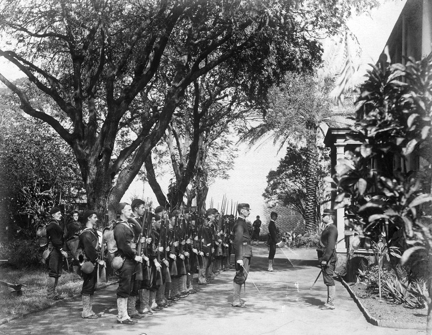
By the late nineteenth century, American expansion was no longer confined to North America.
The Hawaiian Islands had long been an independent kingdom, ruled in the 1890s by Queen Liliʻuokalani. American sugar planters and businessmen had built significant economic influence there, and many favored closer political alignment with the United States.
In 1893, a group of these businessmen, supported by U.S. Marines stationed nearby, overthrew the Hawaiian monarchy and established a provisional government.
President Grover Cleveland opposed annexation, calling the overthrow improper and attempting to reverse it. But when William McKinley took office, policy shifted.
In 1898, during the same year as the Spanish–American War, Congress passed the Newlands Resolution, formally annexing Hawaii as a U.S. territory.
The islands added approximately 6,400 square miles to American territory — modest in size compared to continental acquisitions, but immense in strategic value. Pearl Harbor provided a crucial naval base in the Pacific, offering a midpoint between the American mainland and Asia.
Hawaii would become the fiftieth state in 1959.
Yet the annexation remains controversial. In 1993, Congress formally acknowledged and apologized for America’s role in the 1893 overthrow. For many Native Hawaiians, the loss of sovereignty is still an unresolved historical grievance.
Hawaii marked a turning point. The United States was no longer merely expanding across land. It was projecting power across oceans.
The transformation from continental republic to overseas empire was now fully underway.
The Spanish–American War (1898): America Becomes an Empire
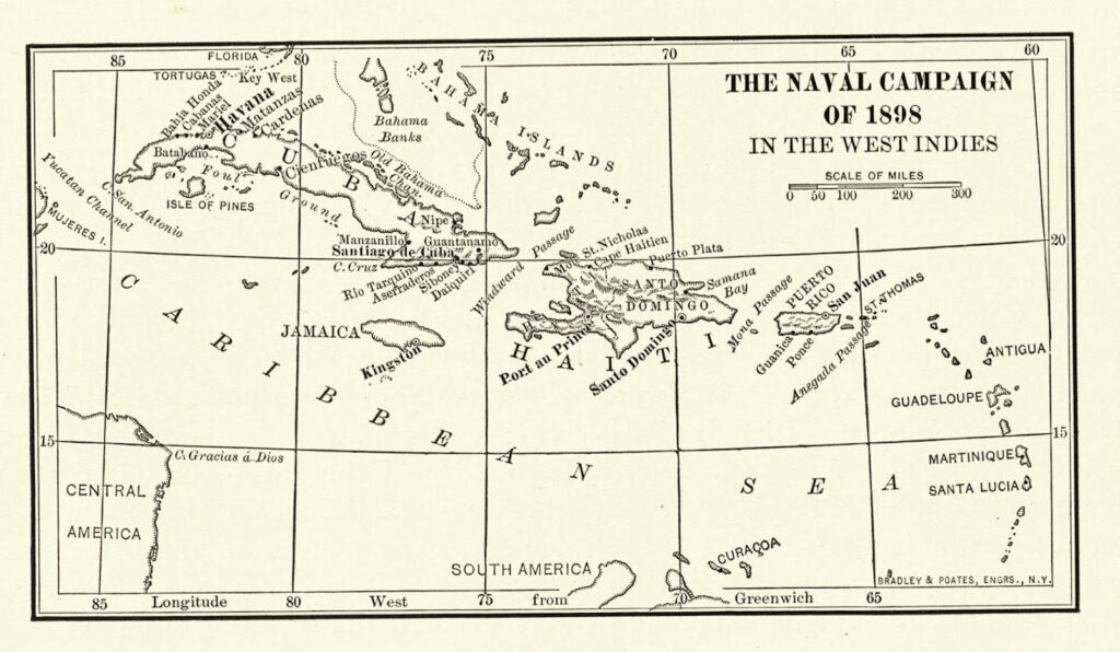
In 1898, a single explosion accelerated America’s transformation into a global imperial power.
When the USS Maine exploded in Havana Harbor, tensions between the United States and Spain escalated rapidly. Sensationalist newspapers blamed Spain, fueling public outrage. “Remember the Maine” became a rallying cry.
Under William McKinley, Congress declared war.
The Spanish–American War lasted only a few months. American forces defeated Spain in both the Caribbean and the Pacific. The conflict ended with the Treaty of Paris.
Under its terms:
- Spain ceded Puerto Rico and Guam to the United States
- The Philippines were transferred to U.S. control for $20 million
- Cuba gained formal independence but remained under heavy U.S. influence
Puerto Rico and Guam remain U.S. territories today.
The Philippines, however, resisted American rule. The Philippine–American War followed, marked by brutal fighting and significant casualties on both sides. The islands would not gain independence until 1946.
This expansion was fundamentally different from earlier acquisitions. It was not about settling contiguous frontier lands. It was about overseas territory, naval power, and influence across the globe.
For the first time, the United States possessed colonies thousands of miles from its shores.
The era of continental expansion had ended. The age of American empire had begun.
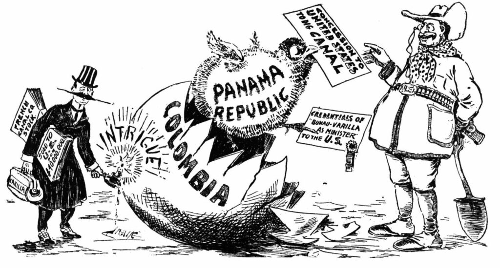
The Panama Canal Zone (1903): Engineering and Intervention
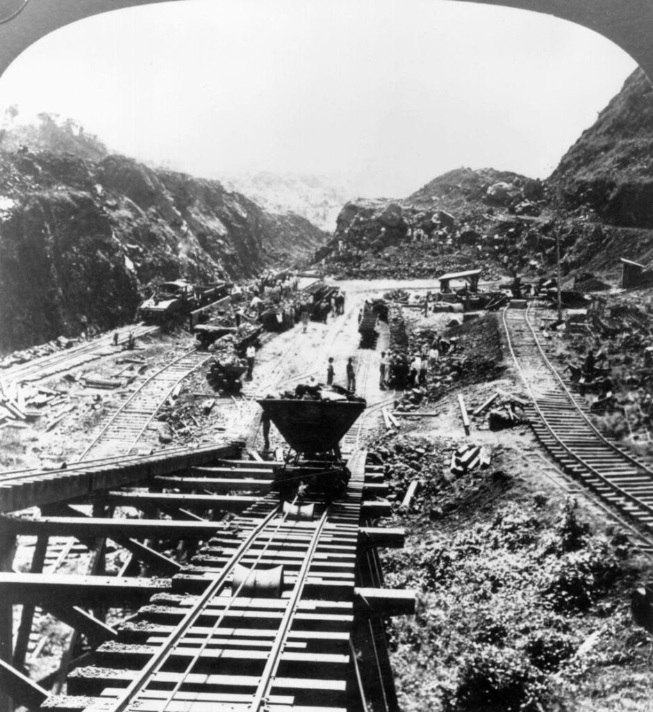
By the early twentieth century, the United States possessed territories in both the Atlantic and Pacific. But moving naval ships between them required a 13,000-mile journey around South America.
President Theodore Roosevelt had a solution: build a canal through Central America.
Initially, negotiations focused on Panama, then a province of Colombia. But Colombia rejected the proposed treaty that would grant the United States rights to construct and control a canal.
Roosevelt responded decisively.
In 1903, Panamanian rebels declared independence from Colombia. U.S. naval forces positioned nearby prevented Colombian troops from suppressing the uprising. Within days, the United States recognized the new Republic of Panama.
Soon after, the two nations signed the Hay–Bunau-Varilla Treaty, granting the United States control of the Panama Canal Zone in exchange for $10 million and annual payments.
Construction of the Panama Canal was an engineering triumph. Completed in 1914, it revolutionized global trade and naval strategy. Ships could now pass between the Atlantic and Pacific in hours instead of weeks.
Roosevelt later summarized the episode bluntly: he had “taken the Canal Zone.”
For decades, the canal symbolized American influence in Latin America. In 1977, President Jimmy Carter negotiated treaties returning control of the canal to Panama, a transfer completed in 1999.
The Panama Canal Zone was not a traditional territorial annexation like Louisiana or Alaska. But it reflected the same logic of expansion: strategic geography justified assertive action.
The United States was no longer merely expanding its borders. It was reshaping global infrastructure to serve its power.
The U.S. Virgin Islands (1917): Strategic Caribbean Security
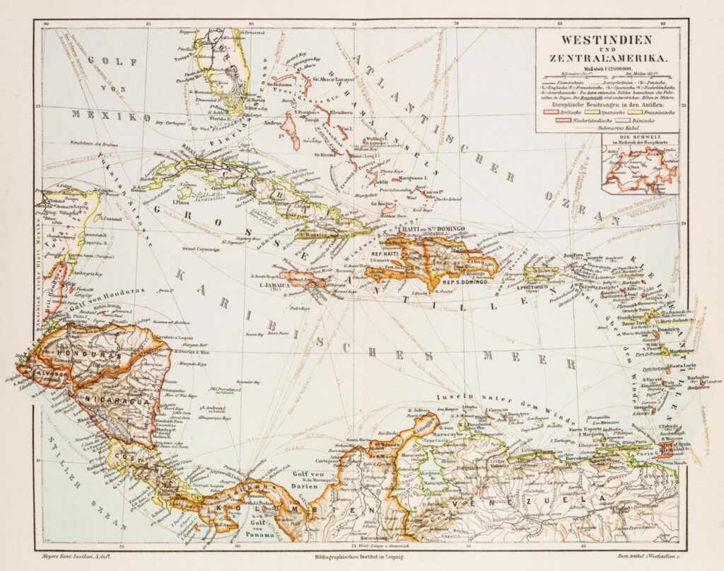
During World War I, American expansion briefly returned to a familiar method: purchase.
At the time, Denmark controlled a small Caribbean territory known as the Danish West Indies — the islands of St. Thomas, St. John, and St. Croix. Though modest in size, their location was strategically important. They sat along key sea lanes near the approaches to the Panama Canal.
President Woodrow Wilson worried about German naval activity in the Atlantic. German submarines were active, and there was concern that Denmark — neutral but vulnerable — might lose control of the islands to Germany, creating a potential threat in the Caribbean.
In 1917, the United States purchased the islands for $25 million in gold. The transfer formally renamed them the U.S. Virgin Islands.
The acquisition added only 133 square miles of territory, but its strategic value outweighed its size. The islands strengthened American naval positioning in the Caribbean and reinforced security around the Panama Canal.
Unlike earlier continental expansions, this purchase was not about settlement or farmland. It was about military positioning in an age of global warfare.
With the Virgin Islands secured, the United States had largely completed its territorial expansion.
Yet one more modern question remained — not about conquest, but about strategic acquisition in a changing world.
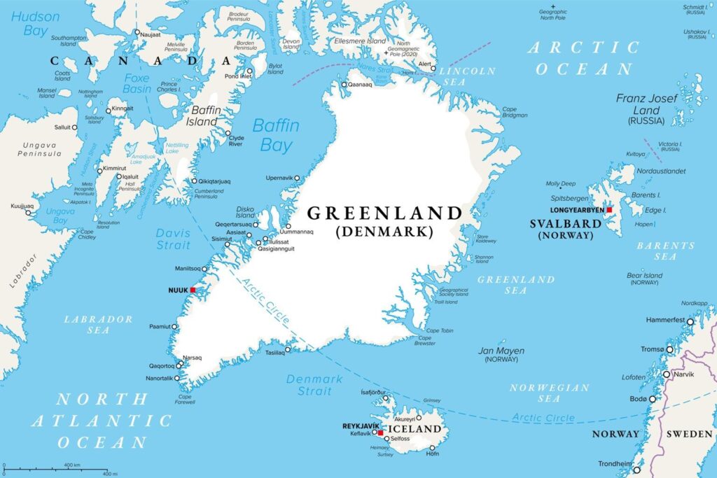
Greenland Proposals: Modern Strategic Ambition
Although major territorial expansion largely ended after World War I, interest in strategic geography never disappeared.
Greenland — the world’s largest island — has long occupied a unique geopolitical position. Though geographically part of North America, it is an autonomous territory within the Kingdom of Denmark. Its location in the Arctic places it between North America and Europe, near emerging polar shipping routes and beneath air corridors critical to missile defense.
In 1946, shortly after World War II, Harry S. Truman offered Denmark $100 million to purchase Greenland. Denmark declined. Still, the United States maintained military access, eventually establishing Thule Air Base as a key Cold War installation.
More than seventy years later, the idea resurfaced.
In 2019, Donald Trump publicly expressed interest in buying Greenland, citing national security and resource potential. Danish leaders rejected the proposal, calling the territory not for sale. The discussion sparked international debate and briefly strained diplomatic relations.
The renewed interest was not arbitrary. Climate change is opening Arctic sea routes and revealing access to rare minerals. Meanwhile, Russia and China have increased their Arctic presence. Greenland sits at the center of this emerging strategic competition.
Unlike earlier acquisitions, modern proposals face significant political, legal, and ethical barriers. Greenland has its own government, and its population has the right to self-determination. Any transfer would require democratic consent.
Still, the persistence of the idea illustrates a broader truth: territorial strategy remains central to presidential thinking, even in the twenty-first century.
Conclusion: Expansion as Presidential Strategy
From the Louisiana Purchase to the Treaty of Guadalupe Hidalgo, from the annexation of Hawaii to the acquisition of the U.S. Virgin Islands, the growth of the United States was never accidental. It was the result of deliberate presidential decisions made in moments of opportunity, crisis, and ambition.
Sometimes expansion came through negotiation and payment. Sometimes it followed military victory. At times it relied on local revolutions, diplomatic pressure, or the weakness of rival empires. But in each case, geography was treated as power.
Territory meant control of rivers and ports. It meant access to trade routes and natural resources. It meant strategic positioning in times of war. It meant shaping the future balance of power.
The early republic expanded to secure its survival. The nineteenth-century nation expanded to fulfill continental ambition. By the turn of the twentieth century, the United States expanded to project global influence.
The map of the United States — stretching from the Atlantic to the Pacific, from the Arctic to the Caribbean — is not simply a backdrop to history. It is the product of it. And behind nearly every line drawn on that map stood a president willing to reshape it.