
Reading Time: 29 Minutes
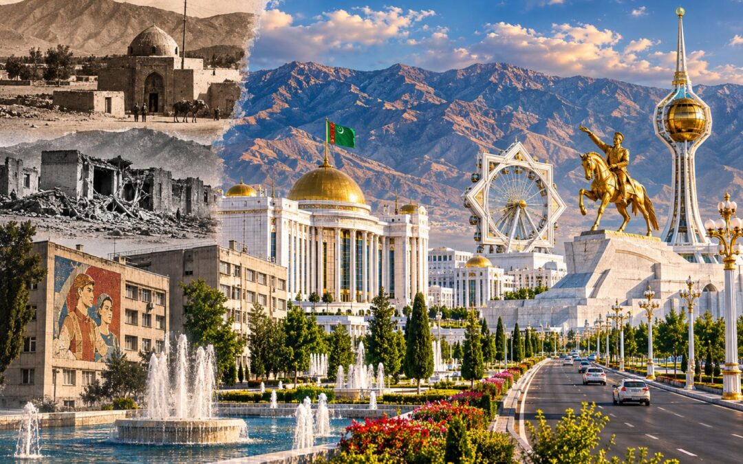
In the capital of Turkmenistan, a visitor can travel along enormous avenues bordered by flawless white buildings, symmetrical gardens and fountains that seem determined to defy the surrounding desert. Government ministries resemble palaces. Monumental arches rise above largely empty plazas, while golden statues and record-breaking structures celebrate a succession of presidents. From certain vantage points, Ashgabat looks less like an ordinary city than an architectural model brought to life at extraordinary expense.
Yet more than a million people lived in Ashgabat according to Turkmenistan’s 2022 census. Behind the ceremonial boulevards are apartment blocks, markets, schools, clinics and neighbourhoods where residents manage the everyday problems of work, transport, water and housing. The capital is not an abandoned ghost city. It is a functioning metropolis whose most visible districts tell only part of its story.
The contrast raises questions that a photograph of the skyline cannot answer. Why does so much of Ashgabat look the same? Where did the money for its marble, monuments and sports complexes come from? How did an old oasis settlement become a Russian railway town, then a Soviet city devastated by an earthquake, and finally a showcase for presidential power? Most importantly, what happened to the people and infrastructure that stood in the way of the transformation?
Ashgabat’s history reveals how urban design can communicate political ambitions while concealing the costs of realizing them. The same city that has pursued extraordinary architectural records must still manage an ageing housing stock, a fragile water supply and the earthquake hazard that almost destroyed it once before.
From Oasis Settlement to Imperial City
Ashgabat occupies a narrow plain between the Kopet Dag mountains to the south and the Karakum Desert to the north. The Iranian border lies nearby, and the mountains have long shaped the movement of water, people and goods across this southern fringe of Central Asia. The location provides a habitable strip in an otherwise demanding landscape, but it also constrains the direction in which a large city can expand.
Human settlement around the foothills is considerably older than Ashgabat’s modern administrative identity. The Neolithic farming community at Jeitun, archaeological sites associated with Anau, and the Parthian fortresses at Nisa all demonstrate that the region supported substantial activity long before the nineteenth century. These were distinct settlements and civilizations, however, not successive versions of one continuously existing city called Ashgabat.
Written references to the name and settlements in the Akhal oasis predate the Russian conquest. Nineteenth-century descriptions differ sharply in their estimates of population and the number of houses or tents, partly because they refer to different geographical areas. The city’s official founding date of 1881 is therefore best understood as a marker of Russian imperial administration rather than the beginning of human settlement.
The decisive event took place northwest of the future capital. In January 1881, Russian forces under General Mikhail Skobelev stormed the fortified Turkmen position at Geok Tepe after an earlier expedition had failed. Thousands of Turkmen were killed during the battle and subsequent pursuit, including civilians; the precise death toll is disputed. The defeat broke organized resistance among the Teke around the Akhal oasis and opened the region to imperial control.
Russian troops occupied Ashgabat shortly afterward. In May 1881 the settlement became the administrative centre of the new Transcaspian Oblast, creating demand for offices, barracks, military facilities, housing and roads. The town was tied to the priorities of an expanding empire, and its transformation depended heavily on transport.
The Transcaspian Railway reached Ashgabat in November 1885. Its route connected the Caspian approaches with the interior and eventually linked towns and oases much farther east. Railway construction moved troops and supplies, supported commerce and attracted officials, merchants and workers. A street grid developed around the station, establishing an urban framework whose influence survived into the Soviet era.
Russia’s conquest also changed the political boundaries around the city. An 1881 agreement between Russia and Persia helped define the southern frontier, while military roads and rail construction made Ashgabat a practical base for governing lands farther east. Imperial authority had begun with a violent campaign, but its permanence depended on creating the offices, transport connections and supply systems of a functioning provincial capital.
The Russian imperial census of 1897 recorded roughly 19,000 inhabitants in Ashgabat. The town contained a mixture of Turkmen, Russians, Persians and other communities, with different languages and religious traditions. This diversity reflected both the earlier oasis world and the new movement of people associated with imperial administration and railway commerce.
One especially distinctive feature was a substantial Bahá’í community, many of whose members had roots in Persia. Between the early 1900s and 1908, the community constructed a prominent house of worship, supported by other institutions including educational and social facilities. Later Soviet repression severely curtailed the community’s activities. The building was damaged in the 1948 earthquake and eventually demolished in 1963, illustrating how much of the pre-Soviet and early Soviet city disappeared from the modern landscape.
Alongside commerce and administration, the town developed a distinctive built environment. Railway buildings, commercial streets, places of worship and residential districts existed together without the overwhelming uniformity that would characterize later government projects. A person walking through early twentieth-century Ashgabat would have encountered the signs of a frontier town rather than an elaborate ceremonial capital.
The October Revolution and subsequent civil war brought further political upheaval. Ashgabat became entangled in fighting over the future of the former Russian imperial territories, including a period of anti-Bolshevik rule and limited British intervention in Transcaspia. Soviet power ultimately prevailed, and the city became the capital of the Turkmen Soviet Socialist Republic established through the 1924 national-territorial reorganization.
By then Ashgabat was a real city with streets, institutions and communities, even if it remained modest compared with major Soviet industrial centres. Its later appearance would owe much to planning decisions made after an event that destroyed much of what its residents had built.
The Night Ashgabat Was Destroyed
On the night of 5–6 October 1948, the people of Ashgabat were living in a Soviet city still emerging from the hardships of the Second World War. The railway station, residential streets, government offices and local shops formed an urban environment that had developed over generations. Shortly after one o’clock in the morning, almost all of it was thrown into chaos.
At approximately 1:12 a.m. local time on 6 October, a powerful earthquake struck near the city. A modern seismological reconstruction of the disaster estimates its magnitude at about 7.3 and documents rupture along multiple faults in the Kopet Dag region. The main shock was followed by strong aftershocks, adding to the danger faced by people searching for relatives or trying to salvage possessions.
Much of Ashgabat’s housing was constructed from adobe or brick, materials that performed poorly under the violent shaking. Walls collapsed, roofs fell and narrow streets filled with rubble. Even more substantial masonry buildings suffered extensive damage, while concrete structures and essential infrastructure were also affected. The earthquake struck while most residents were asleep, leaving little opportunity to escape before buildings failed.
The destruction extended beyond private homes. Medical facilities and government offices were ruined, communication systems were disrupted and the railway sustained damage. Rescue workers faced the task of reaching injured people through wreckage in a city whose normal capacity to respond had largely disappeared. Accounts of open spaces being used for emergency treatment convey how rapidly ordinary squares and streets had to serve as improvised hospitals.
For survivors, the immediate emergency was intensely practical. People had to find water, shelter and medical help while identifying the bodies of relatives and neighbours. The danger did not end when the principal shock stopped: damaged walls remained unstable, and subsequent tremors complicated rescue efforts. Accounts of the aftermath describe large open areas being turned into places for treatment, gathering supplies and organizing evacuation.
The disaster also affected settlements outside the city. That geographical spread matters when assessing the number of deaths: victims included people in surrounding communities as well as residents of central Ashgabat. Railway passengers, military personnel and temporary workers further complicated the population figures available to those attempting to count casualties.
No definitive death toll exists. Estimates range from the tens of thousands to more than 100,000, with a frequently cited figure of approximately 110,000. Soviet restrictions on information, uncertain population records and the scale of destruction make any precise number questionable. The uncertainty should not obscure the central fact that the earthquake was among the deadliest disasters of its kind in the twentieth century.
For decades, the full extent of the catastrophe received relatively little public attention within the Soviet information system. The tragedy nevertheless remained present in family memories and in the stories of survivors who had lost relatives, homes and almost everything they owned. The city had to confront both a humanitarian emergency and the practical question of how to exist afterward.
Emergency relief arrived from other parts of the Soviet Union. Aircraft evacuated injured and displaced people, while soldiers, engineers, medical teams and construction workers participated in recovery. Temporary accommodation and improvised production of building materials became necessary while plans for permanent reconstruction were prepared.
Rebuilding a city on a seismic fault created a dilemma. Planners could reconstruct the familiar streets, preserving an established urban pattern, or redesign Ashgabat more radically around safety and new Soviet requirements. In practice, they chose substantial continuity in the road network while changing much of the architecture and residential fabric.
The reconstruction process lasted for years, and new buildings could not restore everything that had been lost. Personal papers, family possessions, neighbourhood landmarks and the continuity of everyday routines disappeared beneath the rubble. Some survivors left permanently, while others returned to streets whose names remained familiar even as their buildings changed. That loss of urban memory helps explain why the old earthquake remained a defining reference point long after the physical rebuilding advanced.
The earthquake also became part of Turkmenistan’s later political memory. Saparmurat Niyazov, who eventually became the country’s first president, lost his mother and brothers in the disaster. His personal history was incorporated into an official narrative that increasingly connected the suffering and recovery of Ashgabat with the nation’s political leadership.
Remembering the dead is different from using their experience as a political symbol. For the families affected, the earthquake was first a human catastrophe. For urban planners, it was also a reminder that a beautiful city is of little value if its buildings and services cannot protect the people who live inside them.
How Soviet Planners Shaped the Modern Capital
The Soviet reconstruction of Ashgabat began with a decision that still influences the city: retaining much of the existing street grid. Planners did not have the resources or practical freedom to erase every route and rebuild from an entirely new blueprint. Roads, property arrangements and surviving pieces of infrastructure made continuity attractive even after such overwhelming destruction.
An early reconstruction plan prepared under architect Nikolai Baranov between 1949 and 1951 preserved the essential geometry of the pre-earthquake centre. Buildings were rebuilt with greater attention to seismic conditions, and low-rise development became prominent in the immediate reconstruction period. The railway remained an important organizing feature, while administrative buildings, residential streets and public institutions reappeared along familiar routes.
Reconstruction produced institutions that would become landmarks in their own right. The rebuilt railway station, completed in the 1950s, helped re-establish the city’s connections with the wider Soviet transport network. Public squares and commemorative spaces also became places where residents could remember the catastrophe and the rebuilding effort. These were not simply decorative additions: the station, roads and service buildings were part of restoring an urban system after near-total collapse.
The city’s appearance was not static. Population growth, increasing traffic and the demands of Soviet government led to further planning revisions in 1958 and 1967. Ashgabat needed schools, clinics, public transport, engineering networks and housing, not merely repaired monuments. Across the Soviet Union, standardized apartment construction offered a relatively economical way to accommodate growing urban populations.
During the 1960s, Turkmen architects began rethinking the direction of expansion. The older city had developed largely around the railway and existing streets, but its environmental conditions placed limits on growth. Summers were extremely hot, land was constrained by the mountains and desert, and earthquake risk complicated decisions about building location and height.
A new master plan approved in 1974 and completed in 1982 redirected much of the future development towards the south and southwest, closer to the Kopet Dag foothills. Architect Ataburdy Kurbanliyev and his colleague Viktor Kutumov worked with specialists from Leningrad on the scheme. In a later account of Ashgabat’s planning history, Kurbanliyev explained that the change reflected more favourable climatic and seismic conditions in that direction.
This matters because the marble capital did not emerge from a completely blank plan drawn after independence. The southward expansion, the use of broad roads and the distribution of administrative and public facilities built upon a framework established by Soviet architects. Later presidents changed the materials, symbols and scale, but they inherited important decisions about where the city would grow.
Soviet planning also left a distinctive residential legacy. Apartment districts contained schools, shops, courtyards, playgrounds and public transport links, providing an everyday urban environment very different from the ceremonial boulevards subsequently associated with Ashgabat. Some developments were monotonous, and buildings varied in quality, but they were designed to accommodate ordinary city life rather than only official spectacle.
The planning documents also addressed the less glamorous work of distributing public facilities. In residential districts, schools and clinics needed to be close enough for people to reach them without crossing the entire city; retail space and public transport had to serve the growing population. Such concerns contrast with the later tendency to judge the city principally by its most dramatic government buildings. Both traditions shaped modern Ashgabat, but they answered different questions about what a capital was supposed to accomplish.
There were limitations. Standardized concrete and masonry blocks require maintenance, and a design that meets a building code when constructed does not remain safe indefinitely without proper repairs. Water pipes corrode, elevators wear out and structural vulnerabilities may worsen as buildings age or undergo undocumented alterations.
Street design created another lasting difference between Ashgabat and older, more compact cities. In ceremonial districts, buildings sit far back from the roadway, with expansive lawns, fountains or paved spaces between the façade and the street. Such setbacks create impressive long views and room for processions, but they also reduce the continuous storefronts and pedestrian activity that make many urban streets feel lively.
The city uses legally defined building lines, sometimes called red lines, to regulate the positioning of structures. These rules affect government and private projects, and even foreign diplomatic premises have encountered constraints. Yet broad roads and formal setbacks should not be described as uniquely authoritarian inventions: the more revealing issue is how they were combined with the later pursuit of monumental uniformity and political display.
By the time the Soviet Union collapsed in 1991, Ashgabat already possessed a recognizable spatial structure. Its railway-oriented centre, southward expansion corridors and residential districts provided the physical foundations for the much more ambitious building programme that followed.
The Creation of the White Marble City
Turkmenistan became independent in October 1991, and Ashgabat remained the capital. Saparmurat Niyazov, already the leading figure in the republic’s Communist Party, consolidated authority over the new state. In architecture, he found a powerful way to represent independence as an achievement personally delivered by the president.
The government adopted permanent neutrality as a central foreign-policy principle, receiving United Nations recognition in December 1995. That abstract diplomatic status soon acquired a monumental physical expression. The original Arch of Neutrality opened in 1998, topped by a gilded statue of Niyazov that rotated to face the sun. It turned a claim about international relations into a highly visible celebration of the man who embodied the state.
Other projects reinforced the same theme. New government buildings adopted a palace-like scale, while parks, broad ceremonial spaces and formal avenues reflected an official ideal of grandeur. White marble became the defining surface of the development programme, giving different institutions a coherent visual identity regardless of their practical function.
The preference for marble was not simply a fashion adopted by independent architects. Government direction made it a standard for prominent new buildings, and the leadership closely supervised the appearance of the capital. The uniformity that visitors notice today emerged from centralized decisions about how national achievement should look.
Niyazov’s broader personality cult supplied the symbolism. Portraits and statues celebrated him as Türkmenbaşy, Leader of the Turkmen, while his book, the Ruhnama, became compulsory reading in important parts of public life. In 2002 the government even renamed months and weekdays after elements of his personal and national mythology. The city became an outdoor extension of the same political programme.
When Niyazov died in December 2006, his successor Gurbanguly Berdimuhamedow reversed some of the most conspicuous measures. The familiar calendar returned, and certain educational restrictions were relaxed. Yet the architectural project did not end. Instead, the new leadership expanded it on an extraordinary scale.
Berd Berdimuhamedow relocated the original Arch of Neutrality away from the city centre and inaugurated a new monumental setting in the southern part of Ashgabat in 2011. The gilded image of his predecessor survived the move. The change was therefore not a rejection of monumental political symbolism but a reorganization of which symbols would dominate particular spaces.
Other landmarks followed. The Constitution Monument reached roughly 185 metres, the Ashgabat television tower rose to around 211 metres, and its enormous star-shaped façade became a Guinness record holder. The Wedding Palace incorporated a large globe, while the Älem entertainment centre housed a record-breaking enclosed Ferris wheel. Public fountains, striking geometric forms and gilded statues added to the impression that the city was competing against itself to produce new superlatives.
The marble record is the clearest example. On 25 March 2013, Guinness World Records documented 543 white-marble-clad buildings within a 22-square-kilometre area, with a combined 4,513,584 square metres of marble cladding. The record measured a defined area and date; it was not a claim that every building in Ashgabat was new, nor proof that every district had received comparable investment.
Guinness also recorded the extraordinary concentration along Bitarap Türkmenistan Avenue, where its 2013 survey counted 170 marble-clad buildings over a 12.6-kilometre stretch. The standardized façade treatment turns the avenue into a continuous composition when viewed from a vehicle or a distant viewpoint. At street level, however, the effect is different: wide separations between buildings, long perimeter walls and formal landscaping can produce large spaces with few of the shops or informal meeting points found on older commercial streets.
The award was presented on 25 May 2013, a date that became Ashgabat City Day. The national celebration tied the capital’s architectural identity to official prestige. A measurable construction statistic had been converted into an annual ceremony about the success of the state.
Berd Berdimuhamedow also acquired his own monumental image. In 2015, the government unveiled a gold-coloured equestrian statue of the president on a high white base, combining the leader’s image with the culturally important Akhal-Teke horse. The building programme incorporated horse symbolism more broadly, celebrating a genuine Turkmen tradition within an increasingly personalized political environment.
Official ideas about visual harmony reached ordinary streets. Reports described police favouring white or light-coloured cars and restricting some darker vehicles; owners sometimes faced pressure to repaint. Rules and enforcement varied over time, so the assertion that every dark vehicle was universally illegal is too sweeping. The underlying pattern was nevertheless revealing: a preference associated with the leadership could influence everyday urban mobility.
The visual hierarchy also affected how the city represented its history. Older quarters and Soviet-era residences did not fit as neatly into the official aesthetic, while recent monuments could be presented as the definitive image of Turkmen national progress. The very coherence of the marble skyline therefore depends partly on what has been rebuilt, screened from view or simply omitted from photographs.
Not every building associated with the programme was useless. Cultural venues, parks, new residences and public facilities can make real contributions to urban life. Ashgabat’s admission to the UNESCO Creative Cities Network in Design in 2023 also recognizes its engagement with contemporary design and professional activity, not simply its marble-covered monuments.
The defining problem is that impressive appearance cannot, by itself, establish whether development has been effective. Ashgabat’s architecture is a remarkably consistent statement about how its rulers want the nation to be seen. Determining whether the city works for its inhabitants requires examining who paid for that statement and what alternatives were sacrificed.
The Economics of Monumental Construction
Turkmenistan’s construction boom was made possible by an economic resource that lies far from Ashgabat’s immaculate streets: natural gas. The country possesses some of the world’s largest proven reserves, and hydrocarbon exports have provided the state with substantial foreign currency. The money supported development, subsidies and public institutions, but it also financed an unusually ambitious programme of prestige construction.
Energy wealth gave the leadership a financial advantage unavailable to many governments. A state controlling valuable exports can undertake large projects without depending on a broad, independently wealthy private economy. In Turkmenistan, however, the concentration of financial authority made it difficult for citizens to determine which projects were chosen, what they cost or whether more useful investments were rejected.
The opacity was not a recent discovery. An International Monetary Fund assessment published in 1999 described a Foreign Exchange Reserve Fund whose spending included national prestige, cultural and urban reconstruction projects. Significant transactions occurred outside the ordinary published budget, and presidential authorization was central to the fund’s operations.
These arrangements matter because a published government building is not the same as a published government account. Citizens may see a completed palace, road or monument, yet have no reliable access to its full construction cost, contract amendments, operating expenses or alternative bids. Without transparency, independent evaluation of the investment becomes exceptionally difficult.
Foreign contractors played major roles in reshaping Ashgabat. The French company Bouygues was associated with numerous prestigious projects, while Turkish firm Polimeks carried out extensive construction including major public and sporting facilities. Their participation brought engineering expertise and international architectural influences, but the public visibility of contract selection and financial terms remained limited.
Financing arrangements can also determine who bears the risk when energy revenue falls. Foreign construction companies may face delayed payments, while the state must still maintain projects already built. Residents, meanwhile, may experience the consequences of fiscal pressure through service interruptions or reduced spending without being able to examine the decisions that created the obligations. These pressures become especially difficult to manage when important financial commitments are not clearly disclosed.
Some allegations concerning construction contracts and inflated costs have circulated through leaked materials and independent reporting. Those accusations should not automatically be treated as proved cases of corruption by every contractor involved. The more firmly established concern is structural: government financial information is insufficiently transparent for independent investigators to verify how value was assessed or contracts were allocated.
The international airport offers a particularly clear illustration of the relationship between symbolism and infrastructure. Opened in September 2016, its new terminal was shaped like an enormous falcon, an image designed to be recognizable from above. The project, constructed by Polimeks, reportedly cost about $2.3 billion and was designed for approximately 14 million passengers annually.
Airports provide genuine public value, even when demand is modest. They facilitate commerce, diplomacy, tourism and emergency transport, and additional capacity can support future expansion. Yet the airport’s scale was extraordinarily ambitious relative to Turkmenistan’s population and historically limited international visitor numbers. Assessing its success requires actual traffic, maintenance costs and long-term commercial demand rather than the size of the terminal alone.
The 2017 Asian Indoor and Martial Arts Games brought another exceptional wave of construction. Ashgabat’s Olympic complex included a stadium with around 45,000 seats, a giant horse-head motif, accommodation, training venues and extensive associated infrastructure. The sports facilities and related development were estimated to cost about $5 billion, a striking sum for a ten-day competition in a country experiencing serious economic pressures.
The Games provided opportunities for international contact and sporting achievement. Their infrastructure could support subsequent events, training and recreation, and construction created jobs. But those benefits have to be weighed against what the same resources might have achieved in healthcare, schools, municipal water networks, regional roads and ordinary housing.
The financing problem becomes sharper when a project is completed but reliable use figures remain unavailable. A stadium with tens of thousands of seats has very different economics if it hosts frequent events than if it opens mainly for official ceremonies. The same principle applies to an oversized terminal, a hotel designed for foreign guests or a landscaped complex needing constant irrigation. Capacity and visual distinction are not themselves evidence of sustained public demand.
Ashgabat also faces substantial recurring costs. Marble façades need cleaning and repair, ornamental landscaping requires irrigation, fountains consume water and electricity, and monumental complexes need security and maintenance. Initial construction costs capture only part of what a city commits to spending when it creates permanent public assets.
Hydrocarbon income has fluctuated with prices, export demand and dependence on particular customers. The World Bank’s country overview describes an economy still heavily reliant on energy exports, with natural gas, oil and oil products accounting for about 84.9% of exports in 2024. Revenue from these sectors cannot simply be assumed to grow indefinitely, and a capital built on expensive ongoing maintenance becomes more vulnerable when export earnings weaken.
Prestige construction has political functions that financial accounting alone may miss. Monumental spaces communicate authority and national achievement; contracts can support networks of economic influence; and projects closely supervised by the president reinforce the idea that development depends on personal leadership. None of those mechanisms automatically makes each completed building worthless, but they change how public investment is selected and judged.
For a city sustained by scarce water, ageing infrastructure and significant social needs, the essential question is not whether the government could afford white marble at a particular moment. It is whether the investments delivered durable improvements for residents, and whether anyone outside the leadership had meaningful power to ask that question before the money was spent.
The People Moved Out of the Picture
Urban transformation does not begin only when a new building opens. It begins when land is selected, property is acquired and existing residents are told what must happen to their homes. In Ashgabat, some of the most troubling consequences of redevelopment occurred long before visitors saw the completed marble avenues.
Residents described demolitions associated with road widening, beautification campaigns, government buildings, luxury hotels, sporting infrastructure and new housing districts. Some received replacement apartments or compensation. Others reported losing property with insufficient payment, inadequate notice or no effective opportunity to challenge the decision.
The problems were not confined to one project. Redevelopment began under Niyazov and continued under Berdimuhamedow, with preparations for the 2017 Asian Indoor and Martial Arts Games accelerating demolition in several areas. The official objective was to present a modern, orderly and attractive capital to domestic audiences and foreign guests.
Satellite imagery offered independent evidence of the scale of the changes. In 2015, Amnesty International documented mass demolitions around the Choganly neighbourhood, showing thousands of structures disappearing in a relatively short period. The organization estimated that tens of thousands of people had been affected by forced evictions. These were estimates derived from imagery and household assumptions, not a complete official list of every displaced person.
The human consequences went beyond the immediate loss of a building. Families could lose gardens, workshops, household businesses, storage structures and the relationships created by years in a neighbourhood. Moving to an apartment elsewhere might provide a newer home, but not necessarily equivalent floor space, land, access to employment or proximity to relatives.
Compensation rules became a particular source of grievance. Authorities often relied on registered property dimensions and officially recorded occupants, excluding extensions or relatives who lived in a home without the required paperwork. An informal addition might represent years of savings and genuinely usable space to its owners, yet have no recognized value when the land was cleared.
In a detailed investigation published in September 2017, Human Rights Watch and the Turkmen Initiative for Human Rights described households whose homes or extensions had been demolished without adequate compensation. They documented cases involving the destruction of gardens and outbuildings as well as entire residences, and found limited access to effective legal remedies.
A home is rarely just the square footage entered in a municipal register. Families may add rooms as children grow, create a small garden, maintain a workshop or adapt the property to care for elderly relatives. Even where an extension lacks formal permission, its destruction can eliminate investments made over many years. Compensation that ignores those realities can replace an address on paper without restoring the household’s previous living conditions.
One case involved a resident whose family home was cleared for a luxury development associated with the Oguzkent Hotel. Her complaint was not simply that the state had replaced one building with another, but that her family had been deprived of a valued property to make room for an elite project. Other affected households were relocated to apartments that did not adequately accommodate all the people who had been living together.
The investigations also documented the experience of residents whose official registration did not accurately represent their households. A family could contain relatives who had lived together for many years without appearing on the appropriate documents. If the government counted only the registered occupants when deciding on a replacement apartment, people who depended on that home could be left without adequate space. The administrative rule thus converted a documentary discrepancy into a lasting housing problem.
The Olympic development intensified these tensions. Officials demanded the removal of garages, terraces, gates and other structures that did not meet the city’s preferred appearance. In some instances, residents reported being required to pay for demolition themselves. A city supposedly being improved for public benefit thus imposed direct financial burdens on people with little influence over its design.
There is a legitimate public interest in building safer roads, improving infrastructure and removing hazardous structures. Unauthorized construction can create genuine legal or safety concerns. Those considerations do not remove the obligation to provide clear rules, fair notice, adequate compensation and meaningful opportunities to challenge official decisions.
Ashgabat’s residents have also faced restrictions that determine who may move into the city and remain there. The Soviet-era propiska registration system survived independence, tying important aspects of employment, housing and access to services to a person’s officially recorded residence.
Turkmenistan’s migration rules require temporary registration for extended stays away from a permanent address. A presidential decision in February 2016 introduced additional work-permit requirements for people arriving in Ashgabat to seek employment. As the US State Department described in its 2024 investment assessment, employers often prioritize locally registered workers because hiring people from other regions involves additional approvals and practical difficulties.
The distinction is consequential. A qualified worker from Mary or Dashoguz may find a job in the capital harder to obtain than a similarly qualified person whose documents establish Ashgabat residence. Registration can also influence access to accommodation, vehicle ownership and other aspects of ordinary life.
Human rights organizations have reported cases of unregistered residents being removed from rented accommodation or compelled to leave the city during police checks. In the run-up to major international events, restrictions on informal workers and people without local documents became especially visible. Not every provincial visitor faces such treatment, but the uncertainty itself can discourage people from seeking opportunities in the capital.
The registration system also creates opportunities for unofficial payments and unequal treatment. If obtaining permission is difficult, households with money or connections may be better placed to navigate the process than those most in need of work. A requirement presented as orderly administration can thereby reinforce social and economic separation.
This creates a disturbing contradiction within the city’s image. Ashgabat is promoted as the capital of all Turkmen citizens, yet access to its employment and housing can depend heavily on where someone is registered. The urban landscape presents a unified national ideal while administrative rules divide those who can freely participate in its opportunities from those who cannot.
Everyday Life Behind the Marble Facades
Ashgabat is frequently called a ghost city because photographs show enormous empty roads and quiet plazas. The description captures the atmosphere of some ceremonial districts but fails as an account of the whole city. According to the official 2022 population census, Ashgabat had 1,030,063 residents. Their lives cannot be inferred from a photograph taken outside a government building on a hot afternoon.
Much of the population lives in apartments or individual houses away from the most photographed avenues. People travel to work, shop in markets, attend schools, visit relatives and use public transport. The city has universities, hospitals, shops, restaurants, sporting facilities and neighbourhood spaces where ordinary life unfolds without marble monuments dominating every view.
Markets and bazaars offer an especially different urban experience. The circulation of food, clothing, household items and services creates the kind of social and commercial activity that is largely absent from monumental government districts. Some households enjoy substantial material comfort, while others face difficulty affording necessities or maintaining steady employment.
The gap between prestige districts and residential areas becomes clearer when infrastructure fails. In December 2024, independent reporting described a broken water main that left many Ashgabat residents without normal water supply and heating for several days during cold weather. Water tankers served affected neighbourhoods, and damaged sections of the network required urgent repair. The incident was a reminder that systems beneath the pavement matter more to daily life than the appearance of the buildings above it.
The same distinction applies to food availability. Independent accounts from different years describe queues for subsidized bread, sugar, oil and rice, sometimes beginning before shops opened. These reports do not establish that every Ashgabat household faced constant shortages; however, they show that even residents of the country’s wealthiest and most heavily promoted city could experience difficulties obtaining basic goods.
Transport policies can also make ordinary errands harder. Reports of campaigns restricting access by private cars to parts of the city describe overcrowded buses and higher informal taxi fares. A measure presented as environmental improvement or beautification may have a very different impact on someone who needs to reach a clinic, carry groceries or travel between residential districts.
Some features of the ceremonial city may contribute to that difficulty. Very wide roads, long setbacks and large blocks increase walking distances and can make journeys less convenient without dependable pedestrian crossings and public transport. Parks and landscaped spaces can provide valuable shade and recreation, but their location and accessibility determine whether they actually help residents during extreme summer heat.
The urban environment also contains important differences between appearance and use. A new public building may be impressive yet rarely occupied, while an old apartment block with an unremarkable façade may house hundreds of people. Without reliable information about occupancy, operating expenses or service delivery, it is impossible to judge the city by its architectural scale alone.
Ashgabat’s digital environment adds a less visible limitation. Internet access has historically been expensive, slow and subject to extensive filtering. Residents may use workarounds to reach outside information, but restrictions on independent media and communication make it difficult to compare everyday experiences publicly or organize around shared problems.
Political controls have affected the city’s public life as well. A rare protest in central Ashgabat in July 1995 was broken up by police, and reports described numerous detentions. Later crackdowns against critics reinforced the risks of organizing publicly. The suppression of dissent matters to urban planning because residents cannot readily form independent campaigns, question redevelopment decisions or insist that neighbourhood needs receive equal attention.
Photography itself can be sensitive. Journalists have reported being detained or harassed while documenting demolitions and other politically inconvenient subjects. Foreign visitors are often advised to avoid photographing government buildings, security facilities and certain other sites. These restrictions further shape the images outsiders encounter: official architecture is highly visible, while the lives of displaced families and deteriorating infrastructure are harder to document.
Among the cases highlighting those risks is photojournalist Soltan Achilova, who reported being detained while documenting the demolition of homes in the Koshi area in 2017. Her experience demonstrated that recording the disappearance of a neighbourhood could itself become contentious. Other prosecutions and harassment of journalists have made it difficult to build a complete public record of how the city’s redevelopment affects individual families.
That imbalance does not mean Ashgabat’s residents are passive or without cultural life. They celebrate family occasions, pursue education and professional careers, maintain markets and businesses, and participate in traditions connecting the capital to the rest of Turkmenistan. Their city is an inhabited social environment, not simply a backdrop for the president’s next ceremony.
The central issue is that some residents have little control over changes that affect their lives. A family can be relocated for a redevelopment project, a worker can be denied the registration needed to take a job, and neighbourhood infrastructure can deteriorate while the state announces another monumental achievement. These are not incidental details hidden behind the marble: they are essential measures of whether Ashgabat functions as a good city.
Can Ashgabat Withstand Its Next Crisis?
Ashgabat’s greatest urban challenge may not be creating another architectural landmark. It may be maintaining the buildings, pipes, roads and public services that already exist while preparing for hazards that no government can prevent by decree. The city faces serious risks from earthquakes, extreme heat, drought and interruptions to its water supply.
The location that first made settlement possible also makes the city vulnerable. Ashgabat stands near active faults associated with the Kopet Dag mountain system, including those responsible for the 1948 disaster. The memory of that earthquake should be more than a national commemorative ritual; it should influence inspections, construction standards, emergency planning and decisions about where and how to build.
A World Bank assessment of earthquake risk in multifamily housing estimated that roughly 115,000 residents lived in particularly vulnerable building types at the time of its analysis. The study identified unreinforced masonry and certain reinforced-concrete-frame structures among the greatest concerns. Its numbers were modelled estimates using the housing data then available, not a fresh census of unsafe buildings in 2026.
Construction age does not automatically establish whether an individual building is dangerous. A well-maintained Soviet-era apartment block may perform better than a poorly constructed newer one, and vulnerability depends on design, materials, alterations and maintenance. But a city with a substantial inherited housing stock needs rigorous inspection rather than assuming that attractive new developments compensate for the condition of older buildings.
The World Bank’s analysis identified particularly serious risks associated with older unreinforced-masonry and reinforced-concrete-frame buildings. The numerical estimate should be interpreted in light of its models and underlying housing data, but it offers a warning against treating urban safety as an issue that concerns only new skyscrapers. Dense residential buildings can concentrate risk among people who have neither the resources nor the authority to inspect structural conditions independently.
The issue reaches beyond dramatic structural collapse. Residents depend on elevators, fire protection, electrical networks, water pipes and safe exits. Damage to those systems can make buildings unusable even when their main structures remain standing. Replacing an old lift is a genuine improvement, but it cannot substitute for checking the building’s seismic capacity or the buried systems serving its occupants.
Water creates an equally serious problem. Ashgabat depends heavily on supplies transferred through the Karakum Canal and associated reservoirs, an arrangement exposed to evaporation, changing flows, sedimentation and demand from multiple users. A UNDP-supported assessment of climate risks in the water sector identified threats to both the quantity and quality of the capital’s drinking water.
The dilemma is particularly striking in a desert city with extensive lawns and decorative fountains. Urban greenery provides shade, improves comfort and can mitigate heat, so removing every planted space would be a poor response. But landscaping and ornamental water use should be assessed against household supply, efficiency, wastewater reuse and the long-term sustainability of the city’s reservoirs.
Climate change is likely to increase the pressure. Higher temperatures raise evaporation and cooling demand while making outdoor journeys less comfortable. Drought and changes in river availability can intensify competition between domestic consumption, industry, agriculture and public landscaping. Maintaining attractive streets is less important than ensuring households and medical facilities have dependable drinking water in an emergency.
The United Nations Development Programme’s 2026 Ashgabat Risk Profile identified earthquakes, mudflows, drought and extreme heat as major hazards. It emphasized that disaster risk reduction and climate adaptation need to become part of ordinary urban planning rather than treated as separate emergency activities after something goes wrong.
The December 2024 water interruption offered a smaller demonstration of how an urban system can fail. A damaged main affected daily routines across numerous neighbourhoods, and restoring the primary supply did not necessarily repair every weakened distribution pipe. An earthquake, extended heatwave or widespread power failure could affect several interconnected networks at once, creating difficulties that would not be solved by replacing one visible component.
Effective preparation would require better information about the city’s building stock and service networks. Governments need to know which structures are vulnerable, where water mains are failing, how hospitals would function after a power outage, and how residents could reach safe shelter. Public disclosure and independent professional scrutiny make those assessments more useful because problems can be challenged before they become catastrophes.
Ashgabat has shown that its authorities can mobilize resources to build extraordinary projects. They have also constructed homes, roads and public facilities that benefit residents. The question is whether the same political and financial energy can be directed consistently towards maintenance, resilience and services that seldom attract international attention.
The contrast between visible records and invisible risks captures the city’s predicament. It is possible to count precisely how many square metres of marble covered a surveyed district in 2013. It is much harder for an ordinary resident to establish when the water pipes beneath a neighbourhood were inspected, whether a public building meets current seismic standards, or how much money was allocated for maintenance.
Those questions are not less important because they cannot be photographed from a helicopter. They are the difference between an impressive capital and a dependable one.
Ashgabat’s story is therefore neither a simple tale of absurd presidential vanity nor evidence that spectacular architecture proves national prosperity. It is the history of a real city whose shape was influenced by an oasis, a railway, a devastating earthquake, Soviet planners and successive governments determined to display their authority in stone and marble.
Its monuments may remain the first things that outsiders notice. The lasting measure of its success, however, will be whether the people living beyond those monuments have secure homes, reliable water, accessible streets and institutions prepared for the next crisis. A city built to impress the world still has to work for the people who call it home.
Last Updated on November 17, 2026 by Aseem Gupta